

ll
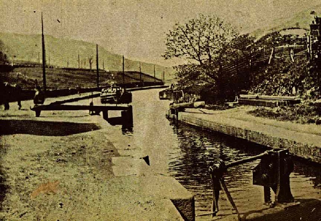
Summit Pound looking East
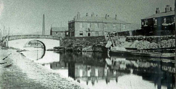
Ben Healy Bridge and the Railway Hotel and the wharf for Cleggswood Colliery
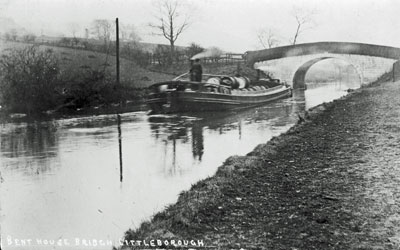
Steam Boat on Rochdale Canal approaching Bent House Bridge heading west
1812 Traffic on canal 199,623 tons
1818 Traffic on canal 317,050 tons
1839 Traffic on canal 875,436 tons
1842 On opening of railway throughout, canal traffic reduced to 667,311
1845 Rochdale Canal carried 1M tons in the year
1880 Tonnage on canal 686,000,
1900 Tonnage on canal 583,000, equal to 50 boats per day
1908 Royal Commission on Inland Waterways Rochdale Canal Co still carrying 100,000 tons pa (coal 30%) and around 20,000 tons was through traffic.
1913 25,130 boat movements had been registered of which 20,635 were for trade between the Bridgewater & Littleborough and only 3, 223 had crossed the summit.
1921 tonnage on canal 180,000 or 12 boats per day
June 1921 Rochdale Canal Co ceased trading in its own right Tonnage down to 120,000 pa
1922 only 8,335 boat movements were recorded with 639 crossing the summit – tonnage 180,000
1929 Last cargo of Raw Cotton arrived at Barge Dock at Rock Nook
1930 Little of through workings on Canal
1937 last two boats traversed the canal from end to end
May 1939 last through passage was a cargo for the standard Wire Works in Sowerby Bridge and an empty boat for sale in Manchester
1941 last commercial operation was 2 narrow boats operated by Kastner-Keller Co carrying acid from Widnes to chemical works in Chadderton and Littleborough
Rochdale Canal through Littleborough
The Rochdale Canal is a broad canal, 14 feet in width running for some 32 miles (51 km) between Castlefield basin in Manchester (where it connects with the Duke of Bridgewater’s Canal) and Sowerby Bridge (where it connects with the Calder Navigation). The canal reaches a height of 600 feet at its Summit and is heavily locked with originally 92 locks. The busiest section of the canal was in Manchester between the Castlefield Basin and Dale Street, junction with the Ashton Canal. To help Please use the links below to navigate this page and for Canal Reconstruction anal restoration look here
The canal through Littleborough
In 1766 a group of local Gentlemen commissioned a survey by John Brindley for a canal. His proposals were for a narrow canal including a Tunnel at Summit. Due to opposition, this early proposal was abandoned.
Some 25 years later, a new group appointed John Rennie FRSE as Engineer with William Crossley, (a local surveyor from Brighouse) to draw up the plans for a Rochdale Canal from Manchester to Sowerby Bridge. A Map of land ownership in 1793 included two proposed reservoirs at Hollingworth. The Committee of the group approached William Jessop who in February 1794 produced his assessment of the Rochdale Canal and advised that it should build as many reservoirs on the moors at Blackstone Edge as the “company of Proprietors shall think proper”. Jessop's advice and his Parliamentary skills led to the 3rd Bill becoming the Rochdale Canal Act on 4th April 1794.
On 17th June 1794 Jessop submitted a report with detailed proposal for building canal with innovative ideas including standardised 10 ft rise locks to minimise waste water and a new ¾ mile long Summit Pound which would be in a 30 ft deep cutting (actually 40 ft) and the depth of water 2 ft deeper to help maintain navigation. Construction of the canal commenced later that year. In 1797 a report to the proprietors indicated "two thirds of (construction) work done" and in August 1798 the Rochdale Canal opened between Sowerby Bridge & Todmorden. In December 1798 the canal opened through Littleborough to Rochdale and by 1799 the canal was opened to Manchester. Finally, on 21st December 1804 the Rochdale Canal opened throughout at a cost in the order of Cost of £500,000.
The Rochdale Canal Company required extensive water storage and eventually built 5 on Blackstone Edge including Whiteholme, Warland, Light Hazzles and Blackstone Edge Reservoirs, Upper & Lower Chelburn and Hollingworth Lake. The latter required a feeder canal and associated pump house to deliver water to the Summit Pound. In in the early days of the canal authorisation was given to increase the capacity of reservoirs by raising dams etc.
The canal through Littleborough
The Littleborough section starts from the swing bridge just west of just west of Warland Upper Lock (No 35) in West Yorkshire to the Swing Bridge at Upper Clegg. Long Lees (Lock 36) and The Summit Inn (Lock 37) are located at the east and west ends of the near 1 ½ mile long Summit Gap, a Glacial Drainage Channel in which the Rivers Calder and Roch rise. Summit Gap and the surrounding hillsides have long been important transport routes with the canal being a key driver in their later development as well as Littleborough and its industry. Beyond Rock Nook the Valley increasingly opens out offering vistas to the surrounding hills where the reservoirs are located.
Including the locks at either end of the Summit Pound, there used to be 12 locks but one at Rock Nook was avoided when the canal was reconstructed. There are still some textile factories at Rock Nook and Green Vale but the Chemical Industries at Long Lees, Cleggswood (Akzo) & Smithy Bridge, Brick & Tile Industries at Summit, Rock Nook and Smithy Bridge have long gone as have the Mills near Durn, Brookfield and in Smithy Bridge (and Clegg Hall) as well as Schofield’s Foundry,many of which are detailed in this website or in our booklets
Swing Bridge No 55 at Little Clegg marks the western end of the canal in Littleborough but a short walk leads to the famous Clegg Hall a site dating back to the 14th Century or earlier.
The working canal served Littleborough for almost 150 years as shown by the traffic details right. Inevitably, stoppages did occur where nature affected navigation through either drought or ice. Happily, the canal has returned to navigation and remains well used for cycling, walking and fishing.
LITTLEBOROUGH HISTORY TRAIL
| History Centre |
| Contact Us |
| Gordon Harvey |
| Town House Mill |
| Richard Jay - Coach Operator |
| William Burrill |
| Richard Jay Haukier |
| Leach - Cycles to Haulage |
| H M Sutcliffe |
| J Grindrod & Son Ltd |
| R Rudge and Son Ltd |
| Canal Restoration |
| Industrial Histories |
| History Trails |
| Littleborough Book |
| Littleborough Books |
| Pubs & Inns |
| Early Schools |
| Non-conformist schools |
| C of E and RC Schools |
| Board and Local Authority Schools |
| Chapels iSummit & Calderboork |
| Closed Chapels Shore Caldermoor Croft |
| Chapels Featherstall Stubley Rakewood |
| Rechabites |
| Clegg Hall & Smithy Bridge |
| Smithy brige Train Distaster |
| Railways in Littleborough Centre |
| Littleborough Viaduct to Summit Tunnel |
| Summit Tunnel |
| Industrial Railways |
| Was summit Tunnel Necessary |
| Blackstone Edge Turnpike |
| Calderbrook Turnpike |
| Doghill to Steanor Bottom Turnpike |
| Todmorden Rd TP |
| Toll Roads |
| Farming |
| List of Farms |
| Co-op - Early Grpwth |
| Coop - Central Premises & Competition |
| Coop in 20th Century |
| Coop Decline & Change |
| LANCTAN |
| Schofield Iron Woks |
| Phoenix Iron Works |
| Ebor Engineering |
| Deanhead Chemical Works |
| Akzo Chemical Works |
| Law's mills |
| Clegg's Shore Mills |
| Consterdine textile Mills |
| Schofield Textile Mills |
| Heap's West View Mills |
| Rayon (Artificial Silk) Manufacture |
| Mills |
| Starring Pottery |
| Summit Brickworks |
| Tetlows Pottery |
| Whittaker Pottery |
| Coal Mining Map |
| Starring Clay and Coal Mine |
| Cleggswood Colliery |
| Shackleton - Coal Merchant |
| Mining around Hollingworth |
| Possible Roman Littleborough |
| Blackstone Edge Roman Road |
| Falllen Heroes not on Littleborough Cenotaph |
| Roll of Honour |
| WW2 Heroes |