

ll

General History of Blackstone Edge Turnpike
The Rochdale to Elland Turnpike was established in 1734 being powered to improve the existing road between Rochdale and Elland (and later Halifax) via Littleborough. It is possible that the trust created or significantly improved the road over Blackstone Edge (see Roman Road), The first tolls were collected in 1734. A further Act in 1754 gave powers to widen the road but the trust was still criticised. For the roads poor state of repair. Further Acts were obtained which did lead to improvements especially in reducing the heavy gradients. The Trust was finally dissolved in 1872.
Use the Links below to navigate this page:
Hurstead to Whitelees Road; Littleborough Centre
Littleborough to the Rake Inn Blackstone Edge Old Road
Blackstone Edge New Road (Halifax Road) .
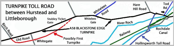
Hurstead to Whitelees Road
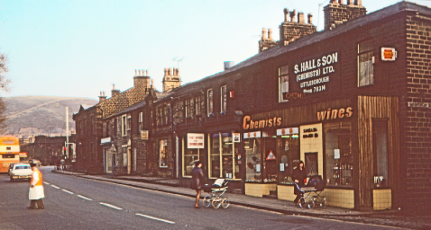
The main A58 road through Littleborough follows the Blackstone Edge Turnpike in its final form before abolition albeit with some minor changes, junction improvements etc. However, the first turnpike largely followed earlier tracks and Pack Horse Ways. The initial route from Greengate to Whitelees Road followed a slightly more southerly route much of which still exists, eg the ‘Old Road in Wuerdle (see sketch map top right). Toll Gates were located along the route with the present names of Greengate and Whitegate suggesting their location although this supposition has not been proven.
During the 1770s ands 1780s, the Trust were determined to undertake improvements between Hurstead and Littleborough which led to the construction of the New Road in Dearnley (pictured right). A new Stubley Ticket Gate was built adjacent to Watling St and New St. The new (2021) housing estate just east of New St had eradicated any trace of the old road at this point. The location of the Whitelees Gate is unclear. But was so located that users of the new (later) Whitelees to Doghills Turnpike Road did not pass through it
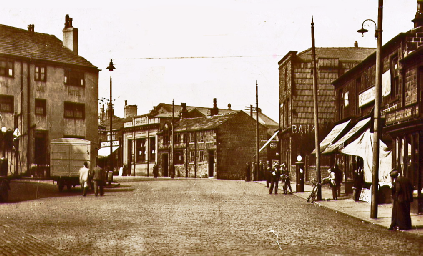
Improvements between 1780 and 1820 which led to the construction of Church St between Morgan St and Hare Hill Road thus avoiding the route over James Hill which passed between the Royal Oak and the Wheatsheaf. The current Holy Trinity Parish Church was built between 1815 – 1820, some 15 yards (15 metres) north of the 1471 church suggesting the Turnpike passed to its south but it is known that the Turnpike passed to the north of the Falcon
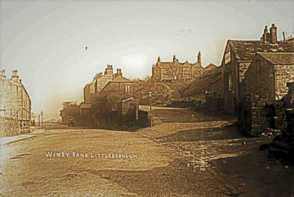
The turnpike passed by Ealees Hall (occupied since 1561) as well as Windy Bank, Bent House etc whose residents had connections and no doubt had a connecting road or track. With the building of the railway viaduct during 1837/8 the road layout next the River Roch bridge was changed and numerous properties incl Ealees Hall were demolished.
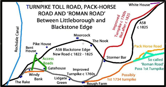
References to the way over the Edge have been recorded from as far back as the Doomsday book in 1070. However, traffic over the Edge increased with Trains of Packhorses carrying goods of £1,000 in the late 17th Century. Pre turnpiking, Daniel Defoe crossed in a storm during 1724. The increased use of wheeled carts and waggons created pressure for a more easily graded route and in the 1760’s the existing route of Blackstone Edge Old Road was created.
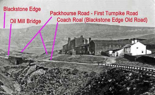
Rough Farmhouse, (painted white in the photograph right) was where the tolls were collected. Drovers watered their animals in the clough below the bridge. The location of the toll building suggests that the first toll road followed the Packhorse Road which runs in front of the cottages (and earlier mill) at High Peak.
The route used over Blackstone Edge by the first turnpike remains uncertain. It is suggested that the so called Roman Road was in fact the work of the Blackstone Edge Turnpike Trust as the original Packhorse Way remains in situ (and un-widened) to the west of the wide stone pavement. Both meet just below the ‘Aiggin Stone’, a way marker cross next to Blackstone Edge Summit.
Around 1760 an easier route over Blackstone Edge was constructed which went from Rough Farm to where Stormer Bar was later built in built 1838) via Oil Mill Bridge (in the above picture). After Stormer Bar (it ran at a lower level before climbing more steeply to the Coach & Horses Once (now the White house)
The growth in coach travel led to further improvements with the current Halifax Road completed in 1820/1. This complemented the recently completed new road between Stormer Bar and the Coach and Horses (or White House as it was increasingly called). In 1825 the whole length of the ‘new’ road from the Rake to The Coach & Horses was complete to the satisfaction of the Inspector General of Mails (for the use by Mail Coaches). Some 6 coaches operated daily between Rochdale and Halifax – Shuffle, Perseverance, High Flier, Defiance, Duke of Leeds and Commerce.
Stormer Hill Bar, formerly Toll Bar Cottage (or Bar House) was originally constructed in 1838 with a porch provided in 1911. The Toll House was constructed where the two Toll Roads crossed as is clearly shown in the photograph (pictured above right). The A58 passes alongside the Bar House with the ‘Old’ road crossing south to north on the west side of the building. Stormer Bar had a weighing machine. Both Turnpike routes combine on the approach to the White House just prior where the walkers are seen approaching the pub which remains to this day, a building whose roots go back to the 17th Century.
Coaches ceased to operation over The Blackstone Edge Turnpike in 1843 following the opening of the Manchester & Leeds Railway through Summit Tunnel
Whilst the A58 remains an important road the M62 a mile or so east now carries much of the Cross-Pennine traffic
Rake Inn where old and new Blackstone Edge (left) roads diverge

| History Centre |
| Contact Us |
| Gordon Harvey |
| Town House Mill |
| Richard Jay - Coach Operator |
| William Burrill |
| Richard Jay Haukier |
| Leach - Cycles to Haulage |
| H M Sutcliffe |
| J Grindrod & Son Ltd |
| R Rudge and Son Ltd |
| Canal Restoration |
| Industrial Histories |
| History Trails |
| Littleborough Book |
| Littleborough Books |
| Pubs & Inns |
| Early Schools |
| Non-conformist schools |
| C of E and RC Schools |
| Board and Local Authority Schools |
| Chapels iSummit & Calderboork |
| Closed Chapels Shore Caldermoor Croft |
| Chapels Featherstall Stubley Rakewood |
| Rechabites |
| Clegg Hall & Smithy Bridge |
| Smithy brige Train Distaster |
| Railways in Littleborough Centre |
| Littleborough Viaduct to Summit Tunnel |
| Summit Tunnel |
| Industrial Railways |
| Was summit Tunnel Necessary |
| Blackstone Edge Turnpike |
| Calderbrook Turnpike |
| Doghill to Steanor Bottom Turnpike |
| Todmorden Rd TP |
| Toll Roads |
| Farming |
| List of Farms |
| Co-op - Early Grpwth |
| Coop - Central Premises & Competition |
| Coop in 20th Century |
| Coop Decline & Change |
| LANCTAN |
| Schofield Iron Woks |
| Phoenix Iron Works |
| Ebor Engineering |
| Deanhead Chemical Works |
| Akzo Chemical Works |
| Law's mills |
| Clegg's Shore Mills |
| Consterdine textile Mills |
| Schofield Textile Mills |
| Heap's West View Mills |
| Rayon (Artificial Silk) Manufacture |
| Mills |
| Starring Pottery |
| Summit Brickworks |
| Tetlows Pottery |
| Whittaker Pottery |
| Coal Mining Map |
| Starring Clay and Coal Mine |
| Cleggswood Colliery |
| Shackleton - Coal Merchant |
| Mining around Hollingworth |
| Possible Roman Littleborough |
| Blackstone Edge Roman Road |
| Falllen Heroes not on Littleborough Cenotaph |
| Roll of Honour |
| WW2 Heroes |