
Littleborough from Cleggswood Hill
Littleborough Station
The station area has undergone many changes over the years with replacement passenger facilities, revised goods yard and coal arrangements, signalling and level crossings for pedestrians. Now just two simple platform lines remain as does the Grade 2 listed viaduct.
Littleborough Passenger Station
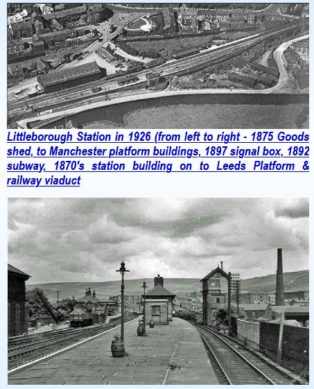
Located on a high embankment the passenger station, has undergone many changes over the years, not always in the best interest of travellers. The earliest station may have had an overall roof and at some date, also had a ticket office under the viaduct with a stepped ramp access to the ‘to Leeds’ platform.
By around 1850 the Leeds platform building had been replaced and was described as being 47 ft long with ticket offices and waiting rooms. In 1873/4 the existing building on the ‘to Leeds’ platform was constructed possibly incorporating parts of the earlier building and included a canopy as shown in the picture opposite top.
The ticket office was reached by a ramped footpath directly off Railway Street, ie the old toll road provided by Mr Smith some 40 years earlier.
In 1892 a new ticket office was built adjacent the new subway with covered stair access to both platforms. On the Up ‘to Manchester’ platform a wooden prefabricated ladies cum general waiting room was provided together with separate gents toilet - see picture right.
Over time numerous changes were made to the passenger facilities and currently both platforms have a large shelter with glass screen walls and leaky roofs. The to Leeds platform retains a heated waiting room, available mornings only. Other changes affecting the station include a new bus turning-circle (pictured right), car park, access ramps and platform lengthening
The adoption of the then (2010) closed and shuttered main station buildings by the Littleborough Historical and Archaeological Society Ltd has transformed the apparently semi-derelict buildings into the History Centre.

Picture above shows from left to right - part of large Good Shed, 1873/4 Stone Station building with Canopy and between canal and Building are the Coal Drops. the Viaduct is far right. For details of the buildings in the background please email - elboroistry@gmail.com. Picture courtesy of Rochdale Local History
Littleborough's Freight Facilities
Coal Drops
There used to be 8 coal drops (for use by local coal merchants) located off Canal St - see picture above - all traces of them have now gone with the road layout totally changed.
.
Littleborough Goods Yard
Goods facilities were developed and expanded over the years with coal being one of the most important commodities. The 1851 OS map shows a large building on the goods yard site but few other details. However, in 1875 a replacement goods depot building was provided perhaps prompted to the growing number of mills in Littleborough. It was this building which required the footpath from the very opening of the railway to be diverted. The goods yard (see picture below) finally closed in 1963, the site being used subsequently for the Lo Cost Supermarket in 1992 (later the Co-op).
See this OS Map dated 1930 for the eastern end of the goods yard and much of Littleborough
See this 1930 OS showing the western part of the goods yard and other industrial locations mentioned in this website

Pictures shows the full extent of Littleborough Goods Yard with the 1890s small wooden Waiting/Ladies Building on the island platform. The large white building in the centre of the picture with the tall chimney is Python Mill
Signal boxes
What signalling was provided at opening and in the earlier days of operation is unclear but by 1891 there was a signal box just east of the viaduct together. with another at the very west end where the the loop commenced. This situation possibly lasted some 30 years but by 1908 the 2 boxes had been replaced by a central signal box (pictured right - also showing covered step entrance to island platform and wooden waiting room etc). At the same time, 4 tracks were provided between the Viaduct and Summit. The OS maps (with links to them above), show how the track layout changed over time The 3rd platform at Littleborough was taken out of use in 1969 but traces can be seen near to the subway end facing the canal. In October 1971 Littleborough Signal Box was closed with signalling was controlled from Preston Power Box

Littleborough Viaduct
Building of the now Grade II listed viaduct around 1838/1839 saw the demolition of numerous properties incl. Ealees Hall, dating from before 1561. Hollins Brook Lane (marked yellow & PCR on the plan right) was also diverted and asa result the Methodical Piazza , which dated from 1805 had to move its entrance from Hollins Brook Lane to Church Street (the Blackstone Edge Turnpike) by way of a footbridge across the adjacent River Roch. Hollins Brook Lane was replaced by Canal Street which gave access to the Canal and later to the Coal Drops and unofficially to Ben Healey Bridge. the Viaduct itself crosses the Blackstone Edge Turnpike with a skew-arch.
The blue on the map, (which shows the proposed line of the viaduct) shows the River Roch at the top being joined by the Ealees Brook which passes through an arch of the viaduct, The canal is at the bottomof the plan.
The Mural (above right) by Stuart Dawson is located in the Visitor Centre along with 3 others on Littleborough’s Railways.
