
Littleborough from Cleggswood Hill
The Rochdale Canal
through Littleborough
Rochdale Canal
The broad canal (see plan right) is 14 feet in width and runs for some 32 miles (51 km) between Castlefield basin in Manchester (where it connects with the Duke of Bridgewater’s Canal) and Sowerby Bridge (where it connects with the Calder Navigation). The canal reaches a height of 600 feet at the Summit Pound which appropriately straddles the current Metropolitan County Boundary. By crossing the Pennines without a tunnel means it is heavily locked with originally 92 locks. The busiest section of the canal was in Manchester between the Castlefield Basin and Dale Street, junction with the Ashton Canal.
Early History
The early proposal in 1766 was a narrow canal (including a Tunnel at Summit) developed by John Brindley but this attracted much opposition (nothing new even then). Some 25 years later, a new group appointed John Rennie FRSE as Engineer with William Crossley, (a local surveyor from Brighouse) to draw up the plans for a Rochdale Canal from Manchester to Sowerby Bridge. A Map of land ownership in 1793 included two proposed reservoirs at Hollingworth. The Committee of the group approached William Jessop who in February 1794 produced his assessment of the Rochdale Canal and advised that it should build as many reservoirs on the moors at Blackstone Edge as the “company of Proprietors shall think proper”. Jessop's advice and his Parliamentary skills led to the 3rd Bill becoming the Rochdale Canal Act on 4th April 1794.
Building the Canal
On 17th June 1794 Jessop submitted a detailed report with many innovative ideas including a standardised 10 ft rise locks to minimise waste water and a new ¾ mile long Summit Pound which would be in a 30 ft deep cutting (actually 40 ft) and the depth of water 2 ft deeper to help maintain navigation. Construction of the canal commenced late 1794. Three years later a report to the proprietors indicated "two thirds of (construction) work done" such that that in August 1798 the Rochdale Canal could be opened between Sowerby Bridge & Todmorden. In December 1798 the canal opened through Littleborough to Rochdale and by 1799 the canal was opened to Manchester. Finally, on 21st December 1804 the Rochdale Canal opened throughout at a cost in the order of Cost of £500,000.
Water Supplies
Avoiding a tunnel, many 'wide' locks on either side of the Pennines meant a huge demand for water which was to an extent met with extensive water storage in 5 reservoirs on Blackstone Edge including Whiteholme, Warland, Light Hazzles and Blackstone Edge Reservoirs, Upper & Lower Chelburn plus Hollingworth Lake - see drawing right (c) GMRO + RCCo). The lake was able to feed 'Summit Pound' by the construction of a feeder canal fed by a pump house in Hollingworth. whilst the original reservoir were initially thought to be adequate, it was soon necessary to increase the height of the dam walls to increase the volume of water stored.

The canal through Littleborough
Unusually the Littleborough section has a swing bridge at each end. From east to west, it starts from the swing bridge just west of Warland Upper Lock (No 35) and ends at the swing bridge at Little Clegg. The Summit Pound starts at Long Lees (Lock 36) and ends at The Summit Inn (Lock 37). The Summit Pound passes through the near 1 ½ mile long Summit Gap, a Glacial Drainage Channel in which the Rivers Calder and Roch rise. Summit Gap. Besides the canal the Summit Pound now (2026) contains the closed Doghills to Steanor Bottom as well as the 1824 Todmorden Turnpikes with the ventilation shafts of the railway clearly visible. The Reddyshore Scout Gate route and associated packhorse routes largely avoided the floor of the Summit Gap, Just prior to lock 37 are the exit tunnels from the drainage canal and Lower Chelburn Reservoirs. Just beyond the bridge the alternative exit from Lower Chelburn syphons under the canal to reach the River Roch. Beyond Rock Nook the Valley increasingly opens out offering vistas to the surrounding hills where the reservoirs are located. Including the locks at either end of the Summit Pound, there used to be 12 locks but one at Rock Nook was avoided when the canal was reconstructed. There are still some textile factories at Rock Nook and Green Vale but the Chemical Industries at Long Lees, Cleggswood (Akzo) & Smithy Bridge, Brick & Tile Industries at Summit, Rock Nook and Smithy Bridge have long gone as have the Mills near Durn, Brookfield and in Smithy Bridge (and Clegg Hall) as well as Schofield’s Foundry,many of which are detailed in this website or in our booklets see History Trails Nos 1, 6, 9, and 15 (now out of print but still available).

Traffic Growth and Decline
1812 Traffic on canal 199,623 tons
1818 Traffic on canal 317,050 tons
1839 Traffic on canal 875,436 tons
1842 On opening of railway throughout, canal traffic reduced to 667,311
1845 Rochdale Canal carried 1M tons in the year
1880 Tonnage on canal 686,000,
1900 Tonnage on canal 583,000, equal to 50 boats per day
1908 Royal Commission on Inland Waterways Rochdale Canal Co still carrying 100,000 tons pa (coal 30%) and around 20,000 tons was through traffic.
1913 25,130 boat movements had been registered of which 20,635 were for trade between the Bridgewater & Littleborough and only 3, 223 had crossed the summit.
1921 tonnage on canal 180,000 or 12 boats per day
June 1921 Rochdale Canal Co ceased trading in its own right Tonnage down to 120,000 pa
1922 only 8,335 boat movements were recorded with 639 crossing the summit – tonnage 180,000
1929 Last cargo of Raw Cotton arrived at Barge Dock at Rock Nook
1930 Little of through workings on Canal
1937 last two boats traversed the canal from end to end
May 1939 last through passage was a cargo for the standard Wire Works in Sowerby Bridge and an empty boat for sale in Manchester
1941 last commercial operation was 2 narrow boats operated by Kastner-Keller Co carrying acid from Widnes to chemical works in Chadderton and Littleborough

Restoration of the Rochdale Canal in Littleborough
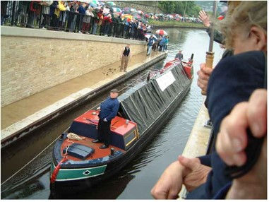
The 1970s saw an early move to restore the Rochdale Canal with the Littleborough Civic Trust forming a 'Canal Group' in 1971. Early work included clearing Pike House Lock during 1973. In July of the following year the Rochdale Canal Society was formed. Clearly, the task of restoring the Rochdale Canal would be massive as Motorways and other roads had been built across the canals alignment, numerous bridges culverted and at the Manchester end numerous locks had been infilled with concrete to reduce drowning's. A start occurred on 5th July 1976 when the Government Manpower Services Commission funded pilot scheme wherein school leavers worked on canal restoration. It was just a pity that the training basically consisted how to use picks and shovels replicating original methods rather than training how to use modern equipment. See picture bottom left. After the initial work, things lapsed with little ongoing work in Littleborough. However, by 1990 a 13 miles section of the Rochdale canal in West Yorkshire was restored to navigation as was Oldham’s short section. By 1992 the canal was re-opened from Summit to Littleborough but much work remained. In 1995 the Rochdale Canal Trust made an unsuccessful attempt to access £23 million grant from the Millennium Fund but this didn’t stop progress in West Yorkshire where in 1996 the Rochdale canal was reconnected to national network at Sowerby Bridge. Eventually, real progress occurred within Greater Manchester with in 2001/2 Ben Healey and Smithy Bridge canal bridges restored. Further work outside Littleborough meant that the Canal restoration was completed and formally re-opened on 1st July 2002 by Fred Dibnah (pictured bottom right). Picture middle bottom shows lock 48 before restoration.


NEXT PAGE
Select this paragraph to add your own text. Just drag and drop or click here to add this paragraph to your site, then you can add your own content and make changes to the font.